Pairing Skid Steers with Drones: Future of Site Surveying Efficiency
The present earthmoving environment is rapidly changing, propelled by the demand for low margins, perfect accuracy, and shortened production schedules. Machines have been the strongholds of the heavy equipment industry for many years, serving the versatile purposes of earthmoving, grading, and material management. Let’s understand the latest technology of skid steers with drones and how it helps in site surveying before project finalization.
Their raw power and multi-tool capabilities have made compact track loaders and skid steer loaders the most common pieces of heavy equipment. However, a productive skid steer can only be as effective as the geographic data that directs its bucket. Traditional surveying methods—such as manual stakes, string lines, and handheld GPS rovers—often lead to logistical bottlenecks, human errors, and expensive reworks.
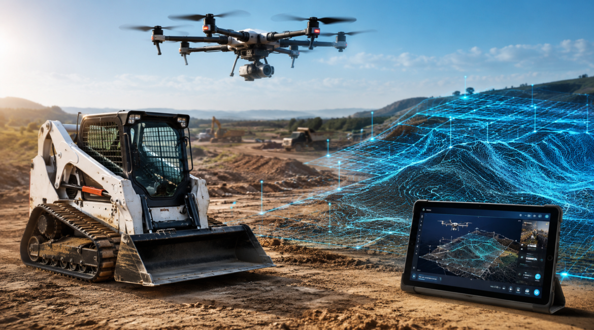
By connecting heavy ground vehicles with Unmanned Aerial Systems (UAS), a.k.a drones, sites would be able to create one combined aerial-to-ground digital workflow. Aircraft are the aerial data engines that deliver to the ground heavy machinery the exact coordinates, volumetric calculations, and latest structural assessments.
Therefore, taking the integration of these two radically different elements, the guesswork is completely removed from earthmoving, allowing operators to perform the various earth altering passes with minimum waste.
Top Features of Pairing Skid Steers with Drones
1. Faster topographical mapping and job site readiness
The ground must first be thoroughly analyzed, mapped, and checked before a skid steer can be allowed to operate on a raw job site. One of the biggest disadvantages of traditional surveying personnel is that it can take them days or even weeks to cover a large property with complex topography on foot, while the weather is changing and there is also the risk of a hazardous terrain. Drones will not only cut down the time of fieldwork, but also help obtain quite an accurate map of the terrain.
- Accelerated spatial data capturing: Utilizing compounds such as LiDAR (Light Detection and Ranging) and high-resolution cameras, drones can cover large acreages in a matter of hours, producing site maps that can be relied upon with hardly any time spent on processing the images.
- Ortho mosaic and Elevation Models: Aerial images are converted into point clouds and 3D digital surface models (DSMs) that display features such as drainage patterns, elevation levels, and possible obstructions that are concealed.
- Date Machine Guidance Integration: These aerial maps are transformed into accessible 3D surface files (e.g., .TTM or .DXF formats) that can be loaded right into the GPS-guided grade control systems of current skid steers.
2. Real-time tracking of volume and material management
Material stockpiles, such as dirt, gravel, mulch, or crushed concrete, are a constant logistical issue that must be dealt with at any construction, agricultural, or civil engineering site. An accurate knowledge of the material stock prevents over-ordering as well as enables the most effective deployment of machinery. Volumetric assessments from above can be carried out very precisely by drones, which then determine the daily workload of skid steer fleets below.
- Automated Stockpile Calculations: Drone software is capable of calculating the volume of irregular material piles to within 1-2% of the true volume, relying on aerial photogrammetry, without the danger of manual climbing.
- Earthmoving Logistics at Workstations: By putting their faith in exact drone telemetry, operators no longer have to guess just how many loads a skid steer has to relocate.
- Avoidance of Waste and Rework: Real-time aerial observation uncovers if a zone cut or fill has reached the precise design limit, stopping operators from excavating excess material and having to backfill.
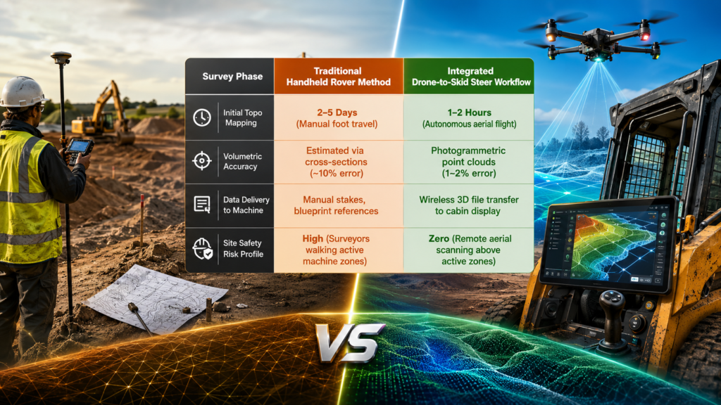
Table: Skid Steers with Drones Survey Phase
| Survey Phase | Traditional Handheld Rover Method | Integrated Drone-to-Skid Steer Workflow |
| Initial Topo Mapping | 2–5 Days (Manual foot travel) | 1–2 Hours (Autonomous aerial flight) |
| Volumetric Accuracy | Estimated via cross-sections (~10% error) | Photogrammetric point clouds (1–2% error) |
| Data Delivery to Machine | Manual stakes, blueprint references | Wireless 3D file transfer to cabin display |
| Site Safety Risk Profile | High (Surveyors walking active machine zones) | Zero (Remote aerial scanning above active zones) |
3. Maximizing On-Site Safety and Reducing Operator Fatigue
Material handling and construction sites are by nature changing and they pose some level of risk to those who directly or indirectly work in them. One of the easiest ways to drastically bring down the number of work accidents is to maintain the distance between the operators of machines and the other personnel who are on foot. Allowing drones to be part of the survey process will provide the required safe distance for ground crews without compromising the confidence of skid steer operators.
- Surveyors Will No Longer Be Walking Through Danger Zones: The aerial capture of data made it possible to replace the crew who carry out ground-level stakeouts so they are no longer exposed to blind spots or steep slopes where skid steers are operating.
- Operators Gain Better Awareness of Their Surroundings: Operators who open updated aerial orthomosaics in plain view on cabin telemetry are able to gain a more comprehensive understanding of changing site hazards such as deep trenches or unstable soil structures.
- Operators Run Machines Less Idly and Lowers Their Stress Level: Because the grade limits are clearly established by the drone’s first layout, skid steer operators have more time for productive work and spend less time idling, awaiting surveyors to re-stake a line, or double-checking manual measurements.
4. Seamless Grade Control and Precision Finish Grading
Finish grading demands tight structural tolerances. Skid steer operators face a dilemma: cutting too deep results in loss of subgrade structural integrity; leaving too much material prevents proper setting of paving or building foundations. At worst, it takes a very large piece of equipment (motor grader) to get these tolerances implemented in grading. Thanks to drone mapping and fully automated grade control systems, compact machinery is now able to replicate these standards at finish-grade level, an achievement only a few years ago for massive motor graders only.
- See the whole process of grading: Drones can be used to carry out the grading process at the site during an an hour when regular work is suspended, such as a lunch break, and can be able to process the work which helps the skate steer crew to release the exact zones which have been “hot” (too high) or “cold” (too low) for the afternoon session.
- Plug and Play Automated Hydraulic: Skid steer equipped with 3D grade control will receive the terrain model verified by the drone, resulting in automatic adjustment of the lift and tilt and that of the attachment blade to impeccably match the design plans.
- Machine Wear and Tear Is Minimally Reduced: Significantly less pass to the desired grade means that fewer replacement components (e.g., tracks, bushings, and pins) in the skid steer can be preserved, and therefore one can expect lower maintenance costs overall.
Frequently Asked Questions (FAQ) – Skid Steers with Drones Project Survey Efficiency
Is drone surveying as accurate as traditional ground methods?
Drones equipped with Real-Time Kinematic (RTK) or Post-Processed Kinematic (PPK) GPS corrections are able to deliver results with horizontal accuracy down to less than an inch and vertical accuracy within 1-2 inches. These measurements are comparable to or even better than those of traditional rover data. Furthermore, a drone operates over a wide area capturing millions of data points whereas a manual survey only involves measuring single points.
Are drone-generated maps compatible with skid steer’s monitor?
Yes. Data generated by drones during photogrammetry or LiDAR is processed using the software platform which then exports it in standard CAD formats (like .DXF, .DWG) or 3D files that are machine-specific. These files can be transferred either using a USB drive or wirelessly via telematics directly into the skid steer’s grade control system.
Do I have to get a special license if I want to operate a drone on a commercial site?
Yes, anyone who operates a drone commercially including site surveying or project monitoring activities in the U.S. must be certified by the FAA under its Part 107 regulations as a Remote Pilot. Other parts of the world have the same or similar requirements for commercial unmanned aviation licensing.
What kind of drone payload is most suitable for very leafy and highly vegetated earthmoving sites?
Heavy foliage sites are best done using the LiDAR option. This is because game of regular camera photogrammetry is only able to map the top of the leaf canopy whereas LiDAR uses light pulses that penetrate gaps of leaves so as to map the ground underneath.
How regularly should one fly the site with the drone in the course of an excavation project?
For busy earthmoving projects, it is common practice to fly the site once a week or even twice a week. This is going to give you fresh volumetric updates, keep track of your skid steers‘ exact progress, keep a clear digital paper trail, and help you easily verify the billing milestones.
Can drone data be used for older skid steer models that do not have GPS?
No to automating 3D hydraulic guidance with drone data for older skid steers. And still, drone data is quite valuable. Managers and operators can get color-coded cut/fill heat maps on a tablet or just print out the highly accurate, updated ones and guide their manual operations from the map.
How do environmental conditions such as wind affect drone site surveying?
Surveying drones of a commercial level are normally designed to be flown in winds that are steady up to about 25–30 mph. Nevertheless, it is a fact that higher winds will make batteries to be used faster and also may cause minor camera stabilization artifacts. Therefore, it is better to do the mapping during weather conditions that are clear and stable for the sake of getting the geometric data to be pure.